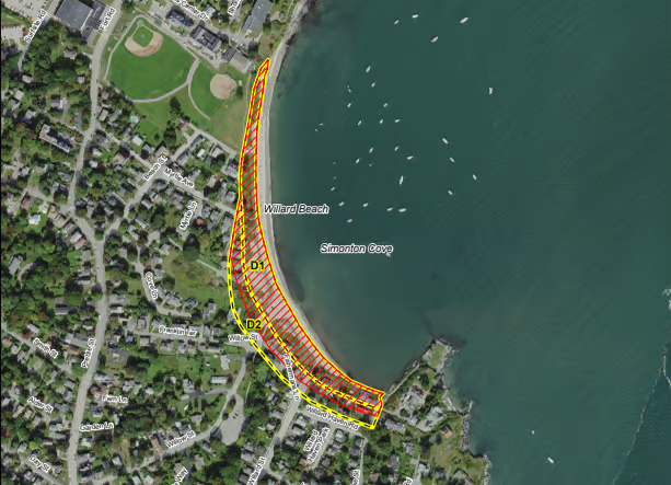
The Maine Board of Environmental Protection voted unanimously in November to provisionally update maps of the state’s sand dunes outlining where special permits are required for construction, despite objections from realtors and some property owners who say many are unaware of the proposed changes.
The new maps “will have a significant impact on hundreds of properties and property owners up and down the entire coast of Maine,” wrote Sandra Guay, an attorney with Archipelago Law, who urged the Board to delay enforcing the change.
Guay acknowledged that the dunes need protection “where appropriate,” but urged DEP “to allow time for real estate brokers, title companies and buyers and sellers of coastal properties to weigh in on the proposed new mapping and to adjust their plans with respect to the purchase and sale of these properties.”
Department officials say the maps are intended only as a guide, and that property owners have always been subject to the “narrative standard” of the Natural Resources Protection Act (NRPA), which regulates development in ecologically sensitive areas.
But DEP Land Bureau Director Rob Wood acknowledged that, for more than a decade, officials used the maps to determine where NRPA applied, which created confusion among some property owners.
“There was never any written guidance provided to staff at any time about how to interpret this,” said DEP Commissioner Melanie Loyzim. “The answer you got about your property could unfortunately depend on which staff person answered the phone when you made that call.”
That lack of clarity has meant that many property owners have been operating under the understanding that the maps delineate where NRPA permits are required, said Board Chair Susan Lessard. “We’ve created part of this problem.”
But Commissioner Loyzim pushed back against the notion there had been insufficient notice about updating the maps, saying the Department has intentionally gone through a major substantive rulemaking process, which requires a public hearing and comment period, even though they did not feel it was legally required.
“The reason that we proposed this rule change was quite intentionally transparent,” said Loyzim, “so that anyone who suffered any remaining confusion would have a very long public process to become aware of the situation.”
The new maps will help staff “apply the law consistently across the board,” said Wood, “and make sure the department staff have clarity and consistency moving forward that we are required to regulate all coastal sand dune systems under NRPA regardless of whether they’re mapped or not.”
Several environmental organizations and local officials were in favor of updating the maps, saying the changes will help clarify the location of the dunes, which are at risk of erosion and submergence from flooding and sea level rise.
“With so much at stake, I implore you to act immediately,” wrote Pownal resident Elizabeth Swain.