Editor’s Note: The following story first appeared in The Maine Monitor’s free environmental newsletter, Climate Monitor, that is delivered to inboxes for every Friday morning. Sign up for the free newsletter to get important environmental news by registering at this link.
Last week, post-gingerbread cookie making and pre-nap, my husband and I bundled the family into the car and went driving around our moderately-sized island, looking for the remnants of disaster. The wind had been howling around us for days, and much of the island (like much of the state) was out of power, with limbs tangled in lines and trees ripped from their roots, blocking roads and driveways. We were lucky to have escaped damage and extensive blackouts, but were antsy to get out of the house, and anxious to see how friends and favorite places had fared.
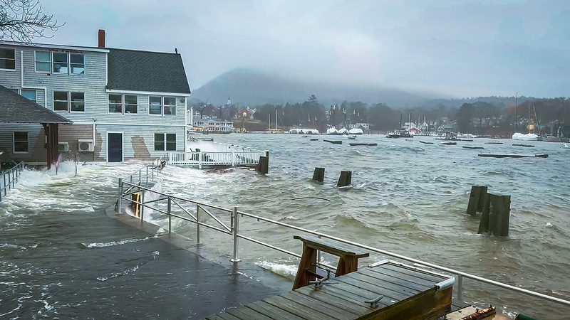
The answer, thankfully, was “mostly okay,” with no serious injuries or property damage, although the specter of burst pipes and spoiled holiday dinners loomed as outages persisted. But not everything escaped unscathed: yawning holes, large enough to lose a leg in, dotted our favorite seaside walking path, where the ocean had scooped up gravel and left rocks and rockweed in its place. At Sand Beach, the storm, combined with a King Tide washed away six feet of sand dunes, exposing remnants of an old fence, and covered the beach with more than 200 feet of seawater, according to a Facebook post by Acadia National Park. Sidewalk bricks were buckled, roads were covered in rocks, and seaweed was everywhere, hanging heavy on fences and in clumps up and down the road.
Mount Desert Island, where I live, was spared the worst of it. Residents of Mile Road in Wells found their street temporarily underwater, with one woman rescued from her car as floodwaters rose. Hundreds of thousands of residents were without power statewide, some for days. Windows shattered under 20 and 30 foot waves at Portland Head Light, and some neighborhoods in Kennebunk were under three feet of water. York and Cumberland Counties are still assessing damage from the storm, but it may reach the threshold for a disaster declaration ($900,000, according to reporting by Maine Public) — the sixth time in ten years that a flood-related disaster has been declared in the state, according to Federal Emergency Management Agency records.
“Flooding is by far the most common property disaster in the US,” said Charles Colgan, an economist and policy analyst who advises communities around the country on dealing with climate change issues. “Heat kills more people, but flooding damages more property.”
As sea levels continue to rise, Maine, said Colgan, with extensive development and vital infrastructure clustered along the coast, will see worse damage, more frequently, a lot of which will come in association with storms. A 1-foot increase in sea level (expected by 2050, if not sooner) will lead to a 15-fold increase in “nuisance” flooding — that is, flooding that occurs absent storms, often referred to as “sunny day” flooding.
We’re not prepared. Fewer than 1% of homes in Maine carried flood insurance as of October 2021, according to a Monitor analysis of numbers provided by FEMA. That’s far fewer than is likely necessary — a recent analysis by First Street Foundation, a nonprofit tech company, found that 26,000 additional properties in Maine are at substantial risk of flooding over the next three decades that are not included in FEMA maps. FEMA representatives have reported that between 2015 and 2019, more than 40% of flood insurance claims came from homeowners outside high-risk areas.
And, as I wrote about earlier this month, flood maps in Maine are often decades old and do not account for sea level rise or extreme rainfall events, which means many property owners may be at risk of flooding and not know it. When FEMA does update maps, it often faces pushback from communities wary of hurting property values or increasing costs for homeowners.
If a disaster is declared, those without flood insurance will at least be eligible for some type of payout, said Colgan, as opposed to none at all (homeowners and renters insurance do not typically cover flood damage). But FEMA disaster awards, which average $5,000 per household, typically don’t come close to approaching the cost of repairs. (The average flood insurance claim, by contrast, is nearly $30,000.)
As the climate changes, we’re also likely to see more downed trees, and thus more power outages, as a result of changing wind patterns, said Peter Slovinsky, a marine geologist with the Maine Geological Survey who has been studying sea level rise and climate change for decades.
“I can’t scientifically say there’s an increase in southeasters,” said Slovinsky, but anecdotally, “We’re seeing more southeasters in the late fall and early winter.” Winds from the southeast, like those during last week’s storm, “expose bluff areas to erosive wave forces that don’t typically see them,” Slovinsky said, and “knock down a lot of trees, because all our trees are basically conditioned for nor’easters.”
“Things that were stable are now unstable,” said Slovinsky. “The changes are staggering.”
To read the full edition of this newsletter, see Climate Monitor: Storms like last week’s expected to become more frequent, damaging as sea levels rise.
Kate Cough covers the environment for The Maine Monitor. Reach her with story ideas by email: [Show Email].