Catastrophic winter storm surges are showing no mercy as the debate drags on about the best remedy for a rapidly deteriorating Machias dike.
Last fall a temporary span was built over the dike after portions of the foundation gave way. Then, in early January, back-to-back violent storm surges flooded Machias, besieging the dike and forcing the town office to relocate.
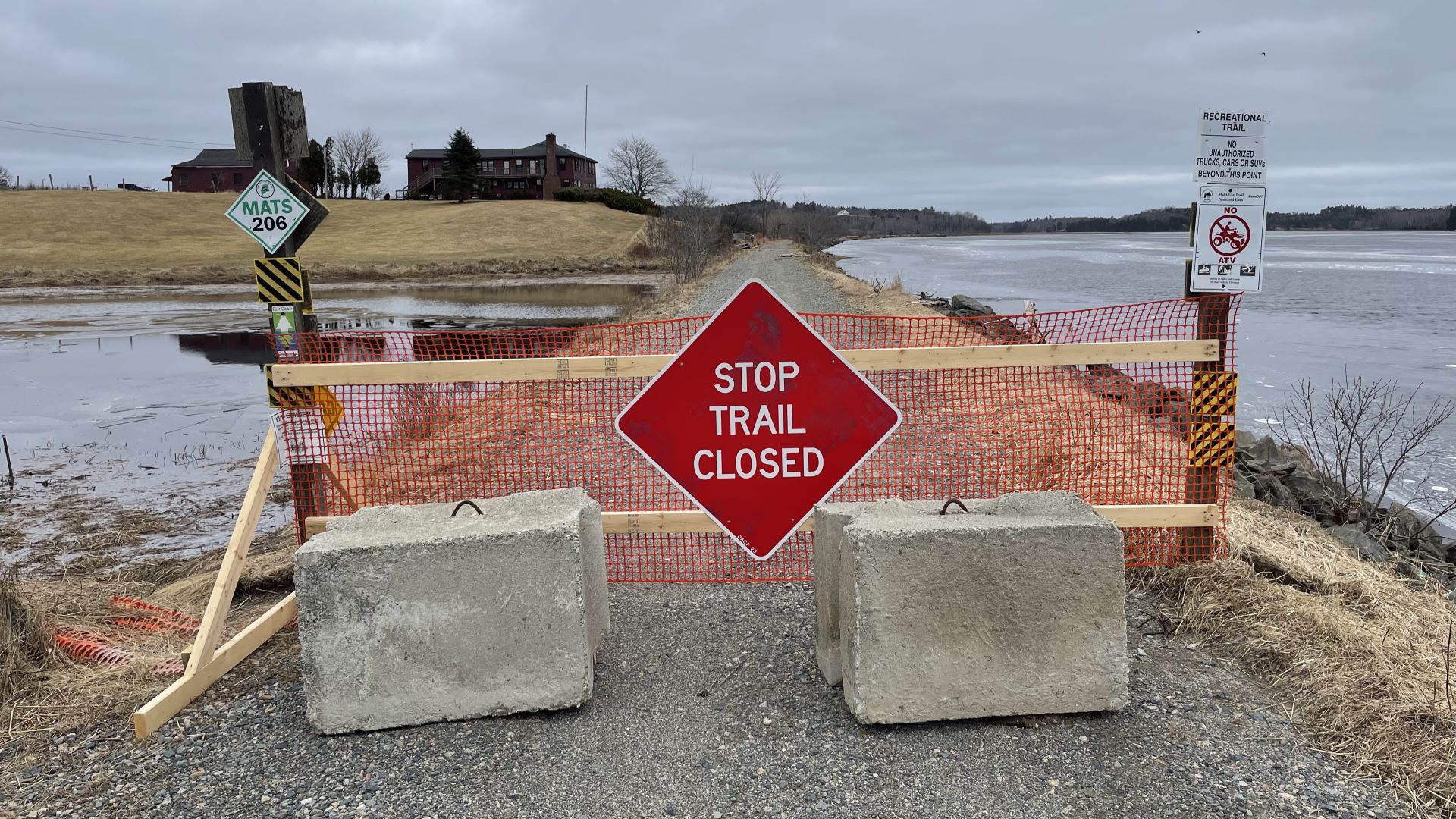
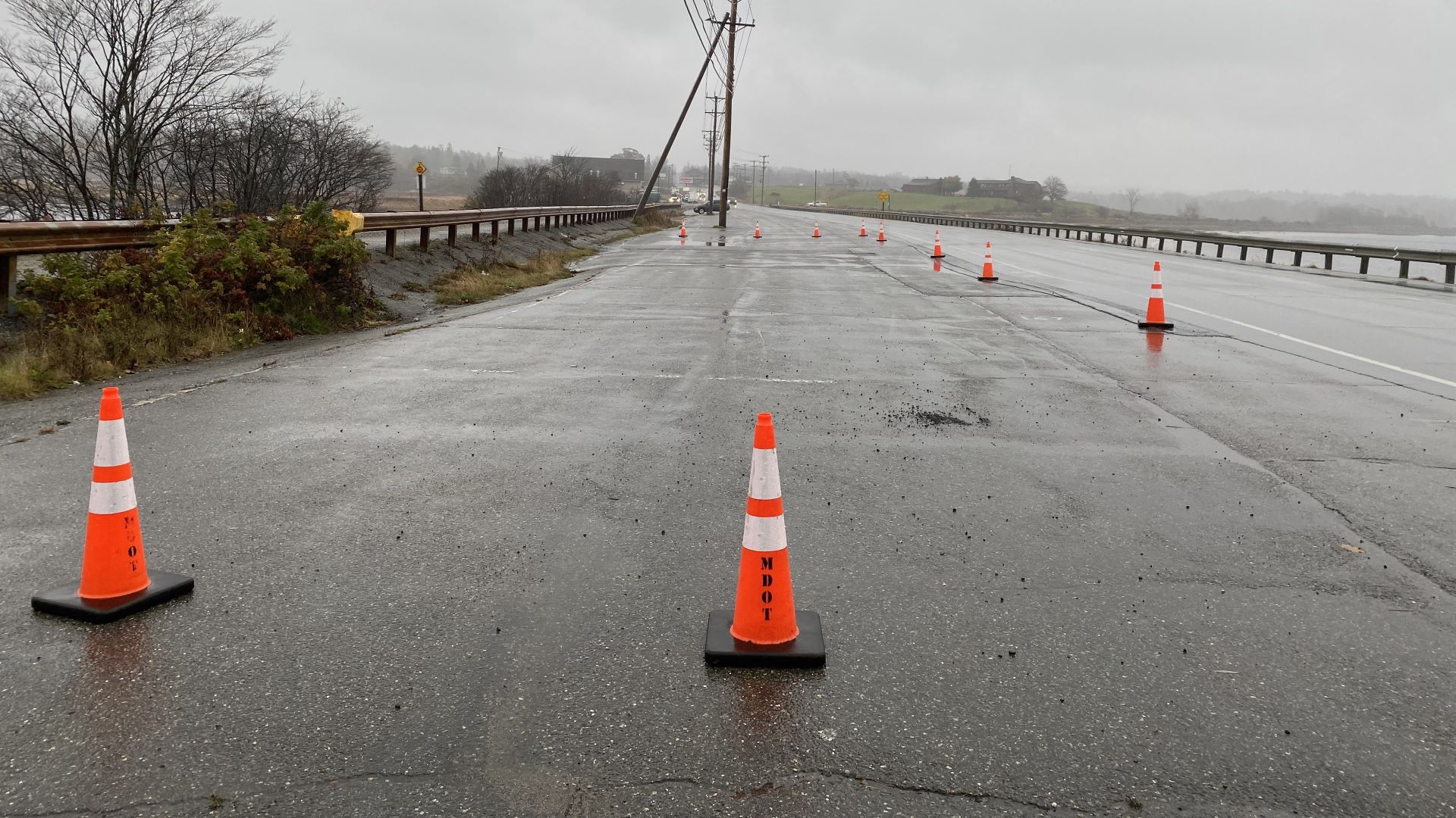
The storm that hit last Sunday further eroded the dike’s foundation and ripped out portions of the adjacent Down East Sunrise Trail, rendering the popular recreational path impassable.
Sunday’s assault got everyone’s attention.
On Monday, nearly two dozen officials from Machias, East Machias, state agencies and conservation groups met on the trail to survey the damage.
“People kept telling me to be patient,” said Brian Bronson, the ATV program supervisor for Maine’s Department of Agriculture, Conservation and Forestry. “I said it’s about time we all get on the ground together and have a conversation.”
Mother Nature gave the group a brutal welcome. Bronson described 30 mph winds with freezing rain and snow as the group trudged roughly four miles over debris, water, rocks and washouts before the intense rising tide and untraversable gulfs made everyone turn back.
He said officials with the Maine Department of Transportation, which owns the trail, took measurements and photos of the damage. Bronson said the plan is to have the trail ready for use again by Memorial Day.
The repairs are expected to cost around $530,000. But the Maine Coast Heritage Trust (MCHT) and Downeast Salmon Federation (DSF) would like to see the trail structure improved, with larger culverts and an additional bridge.
Those upgrades would cost around $1.5 million. The total depends in part on whether the bridge would need to be designed to support train traffic, as outlined in state law, should rail transportation one day return to the region.
Officials say there is money from the Federal Emergency Management Agency to help defray repair costs. But unless a waiver is granted, FEMA rules require the money to be used only for repairs, not improvements.
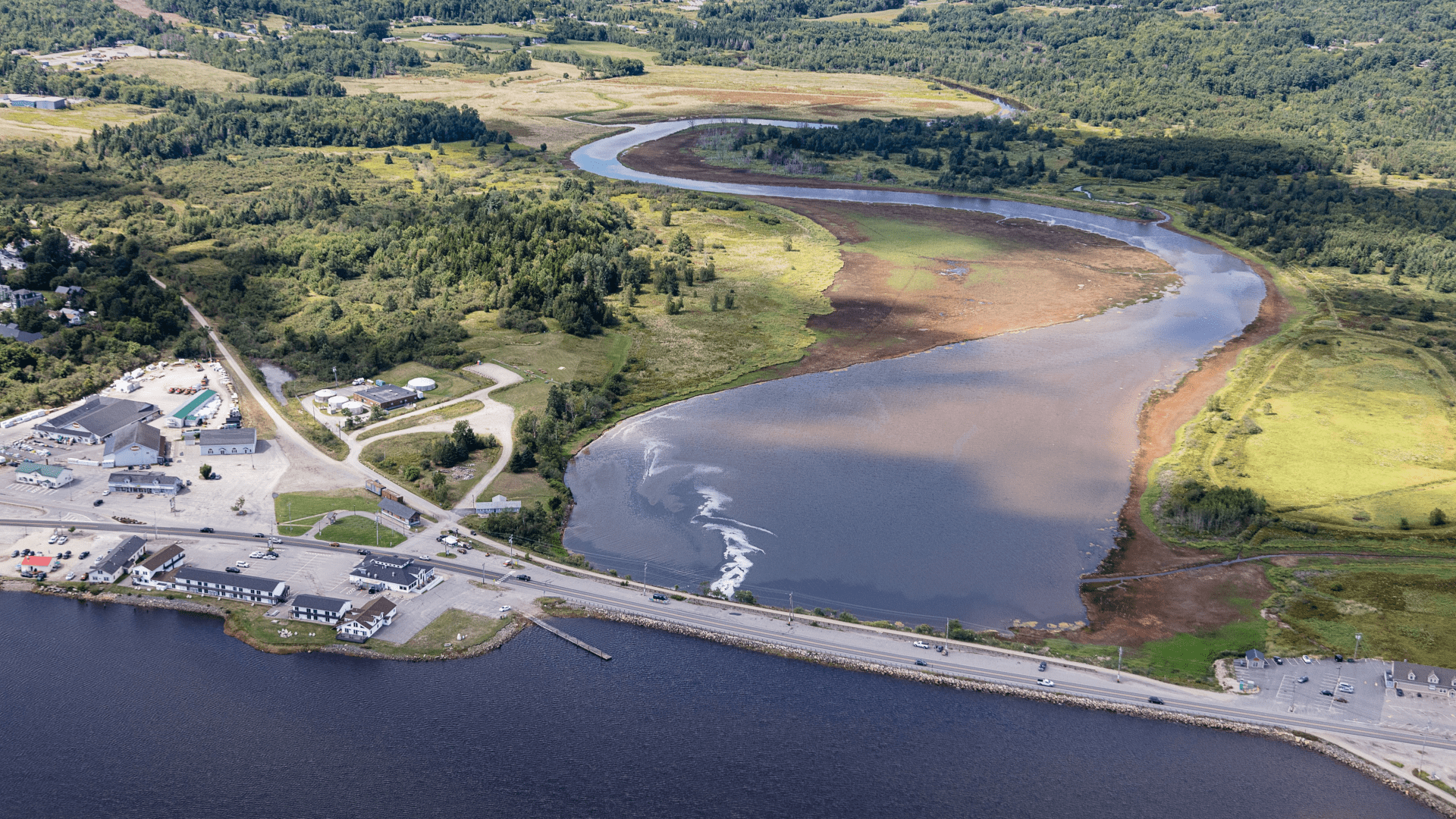
Conservationists say the desired upgrades would protect the trail from future damage, as well as restore the adjoining Schoppee Marsh, by allowing “tidal transparency” — essentially a freer flow of water during high tides, bringing the marsh waters to the same level as the bay waters.
Currently, a railbed from the 1800s chokes the tides, forcing the water to tear apart the trail, bullying its way through.
According to Jacob van de Sande, MCHT’s eastern Washington County project manager, grant money is available through the National Fish and Wildlife Foundation (NFWF) to pay for the work. But he said they need to act now.
“This is like a once-in-a-lifetime funding situation to do the work that we’ve been talking about doing for years,” van de Sande said. “If we wait another five years, we may have missed those opportunities.”
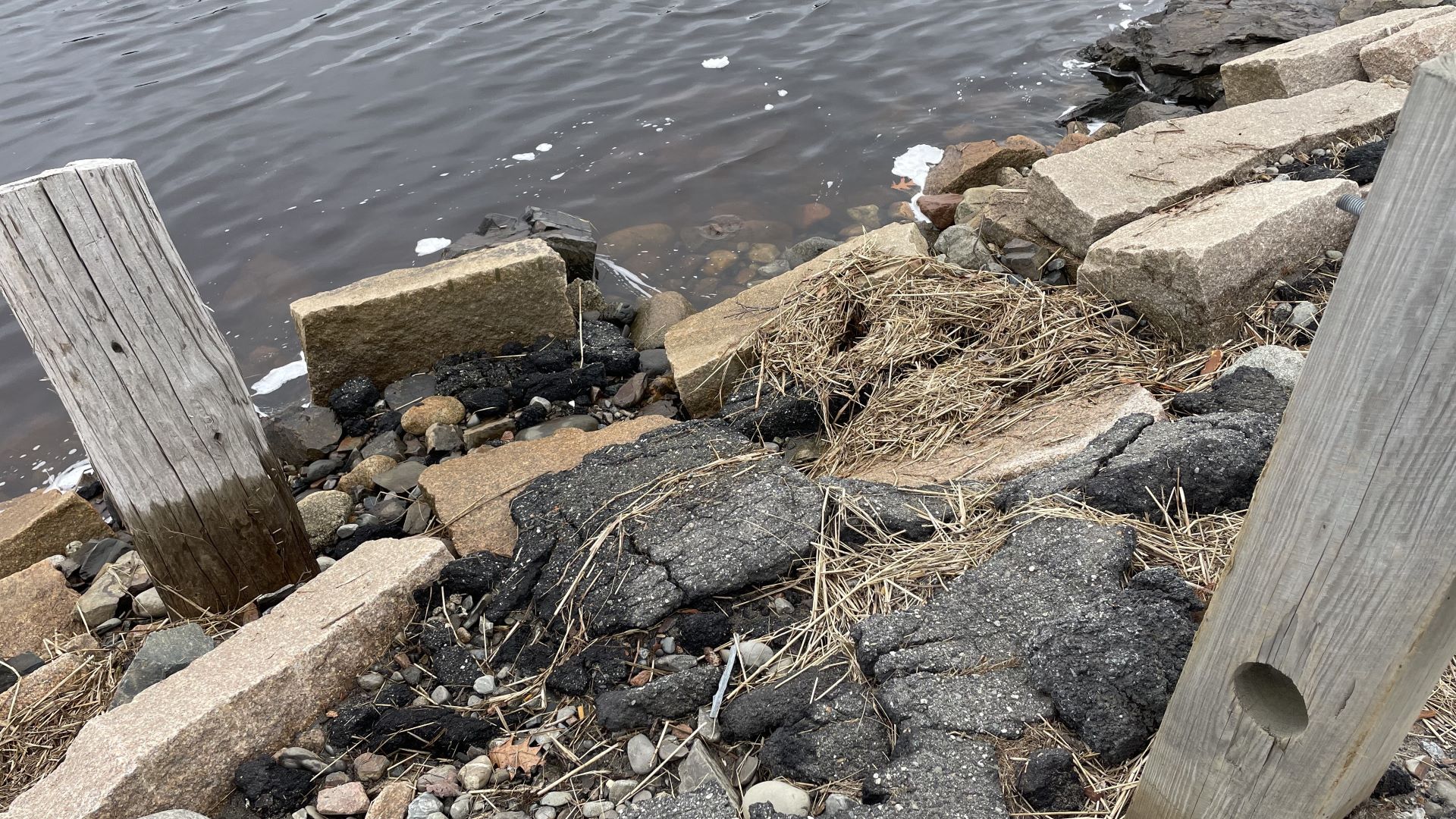
Although the dike was not inspected during the trail visit, officials continue to document its condition. Van de Sande and others said they could clearly see the influence the recent storm had on the 100-year-old dike’s foundation.
Tora Johnson, co-director of the Sustainable Prosperity Initiative at the Sunrise County Economic Council, has studied and modeled the rising seas for 25 years. She and others who observed the storm surge impacts believe that the dike, like the Down East Sunrise Trail, could also wash out.
“You could see water actually sort of peeking out from between the rocks and cracks and asphalt, and you can see the rocks themselves that are part of the dike,” Johnson said. “I’m not an engineer, but its existence is very tenuous right now.”
Town manager Bill Kitchen and a group of stakeholders have met with consultants over the past two years to develop a broad plan to deal with the rising tides. The Musson Group, a Southwest Harbor land-use consultancy, has assisted with the planning, and a final report will be ready in April, according to Kitchen.
From the flood wall and stormwater management to the shoreline and the salt marsh, Kitchen said the town needs everybody on the same page.
“All of these projects have to work together,” Kitchen said. “If they don’t, you know, it’s water, and water will find the way.”
The recent storms have had a devastating economic impact, with the Jan. 10 and Jan. 13 storms causing an estimated $10 million in damages. The cost of the March 10 storm hasn’t been totaled, but repair costs for the failing dike and trail are staggering.
The state Department of Transportation estimates the cost to replace the Civil War-era dike with an in-kind dike — the department’s most recent plan — would run from $25 to $30 million, depending on the final design and fluctuating construction costs.
The existing bridge consists of four box culverts within an embankment structure. The culverts, made of wood and stone, would be replaced with stronger materials and outfitted with tide gates, according to Paul Merrill, the DOT spokesman.
The DOT initially favored a combination design that incorporated a dike on either end of a bridge, which would cost several million more than the in-kind replacement dike.
But the agency reversed course last fall, opting for the in-kind replacement after pressure from landowners and vendors who sell their wares on the dike — everything from antiques to seafood.
Earle Faulkingham sells the catch of the day on the dike several days a week year-round. Faulkingham said he and the other vendors depend on the dike’s steady flow of customers, and he lost money last year by temporarily relocating when the dike was closed.
Angie Garrison, who started her food truck business on the dike, agreed that losing the embankment would hurt vendors, but said much more than money would be lost.
“It’s a day out on Saturday, it’s so social,” Garrison said. “It’s part of what makes Machias special.”
The DOT received even stronger pushback from landowners on Middle River, who want the flow of water from Machias Bay to remain restricted by a dike. Modeling has shown that some landowners’ property would be flooded if a bridge was built.
They also raised concerns about potential contamination from landfills along the river, particularly to the valuable Machiasport clam flats. The landfills were one reason DOT changed its decision, Merrill said, but conservation groups say concerns are unfounded.
The compromise dike and bridge plan, which was designed by MCHT, DSF and others, was presented in 2022. The conservation groups believe it’s the best solution for mitigating flooding, pointing out that the existing dike’s broken tide gates have actually prevented some flooding by allowing water to pass through unimpeded.
This design would also restore a complex ecosystem that spans Middle River and Machias Bay, according to Charlie Foster, DSF’s associate director.
“If you were to return the tide, you would see the restoration of over 400 acres of salt marsh,” Foster said. “It would make it one of the largest salt marsh restoration projects in the entire state.”
The design calls for green spaces, improved vendor space, better ATV access across Route 1 and safe walkways to the Down East Sunrise Trail. About 5,000 ATV riders use the trail each year, as well as equestrians, and thousands of walkers, joggers and cyclists.
The conservation groups say the Down East Sunrise Trail also needs significant improvements, not only because of its recreational value but its relationship to Schoppee Marsh.
DSF is working on a hydrodynamic study that models Machias Bay waters from the Rim Road bridge to Bad Little Falls. The idea is to simulate what would happen if the marshes were opened, and measure the impact on downtown flooding.
This $80,000 study, funded by NFWF, also includes a cost-benefit analysis of various dike alternatives, and should be completed by September, Foster said.
The DOT plans to hold another public hearing this spring.
“This is a complex project that involves a broad array of stakeholders. Public input is an important part of our planning and design process,” Merrill said. “Things can always change, but right now we are continuing forward with plans for an in-kind replacement.”
Meanwhile, various stakeholders have threatened to sue if they don’t get their way, Johnson said, noting there’s no perfect solution.
“A good process means people will come together and make an informed decision, and then everyone will live with it,” Johnson said. “A bad process means the whole project is going to be held up for years because it will be in the courts.”