“For all at last return to the sea,” wrote Rachel Carson, though the words may be little comfort to Maine’s coastal residents watching the effects of the recent back-to-back storms that brought some of the worst flooding in the state’s history.
Emergency management officials are scrambling to assess the damages and prepare, as much as possible, for what may come next.
“We have been surprised at the pace at which this is happening,” said Tora Johnson, geographic researcher and codirector of the Sustainable Prosperity Initiative at the Sunrise County Economic Council.
“No one could have predicted the specific pattern” of the past two storms, she emphasized, although the increasing storm intensity and associated flood heights have been anticipated.
The storm on January 10 resulted in the highest water levels recorded in Machias, being more than one foot over base flood elevation, or the highest point set by the so-called 100-year flood, Johnson says.
That high point has been breached eight times in the past six years — with the most recent three incidents occurring in a time span of just four weeks.
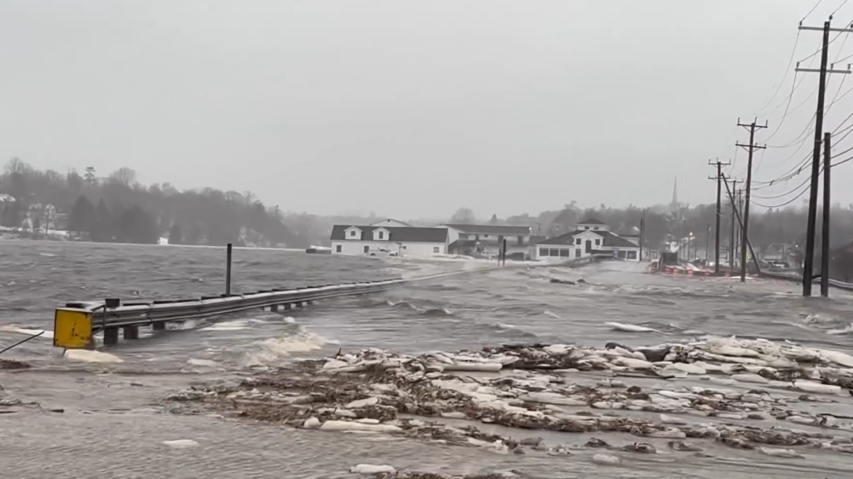
Some towns lost historic infrastructure, such as Milbridge, which saw four or five of its eight piers damaged. In Machias, frozen chunks of ice and seaweed flooded the downtown as the dike and temporary bridge over the Middle River were overtaken by the storm surge. In Addison, the East Side Road flooded as the sea rushed across; the causeway to Deer Isle similarly flooded over and was closed for a period of time.
Around the county, water level records were set. Cutler reached its highest-ever recorded water level at 18.89 feet, and Calais hit its second highest at 15.99 feet. Eastport reached its fourth-highest water level at 23.92 feet.
An accelerating process
Whereas some scientists, Johnson included, have been looking 20 to 30 years down the road for the more extreme effects of climate change, the recent storms have been eye-opening for many, she said.
“This is a much shorter timeframe,” and as a result, “people are paying more attention.”
To illustrate how vulnerable the infrastructure is for coastal towns, Johnson references the wastewater treatment facility in Machias. Even though the tide was high during the January 10 storm, taking place a day before the highest tide of the month, it was still one foot lower than what would be seen during a king tide at its peak.
If the January 10 storm had taken place during a full king tide, Johnson said, then it would have had a “pretty devastating impact on the wastewater treatment plant,” with water flooding into it.
As far as upcoming projects such as the Machias dike replacement, Johnson noted she anticipates that the recent flooding will influence the final design, though it’s difficult to say how much.
The state is currently operating on figures from the Maine Climate Council that foresee 1.5 feet of relative sea level rise by 2050, and 3.9 feet by 2100 — figures that Johnson says are “conservative” and which will likely be greater.
It’s not just a matter of sea level rise, although that is happening in the Gulf of Maine “faster than 99% of all the rest of the world’s oceans,” Johnson said. It’s the increasing frequency and intensity of the storms fueled by human-caused climate change that are the problem.
It’s the type of storm, too. Whereas Maine is accustomed to northeasters, which travel along the coast carrying high winds and precipitation, the recent storms came from the southeast and pushed coastal waters inland.
Recent storms have brought significantly more rain than snow, Johnson added. “We’re seeing a definite increase… in the number of storms that involve rain in the winter, and also really, really strong pulses of rain,” which were far more unusual in prior time periods.
The different storms, their frequency and intensity are all partly influenced by El Nino and the North Atlantic Oscillation (NAO), both of which are global weather cycles that are happening concurrently this year.
Because of human-caused climate change, however, El Nino and the NAO are happening more regularly and vigorously, too, Johnson noted. “The whole thing is speeding up.”
In summary, Johnson said, “The storms are coming in with greater force, they’re coming in with greater frequency, and they’re happening on top of a higher sea,” and that’s what coastal communities and emergency officials are up against.
Building back better
As with the upcoming dike project in Machias, builders have to balance the anticipation of sea level rise and storm surge with project cost, Johnson said. “You have to factor in risk tolerance,” she explained, along with the lifespan of the project, noting that there’s a measure of unpredictability at play.
As an example, Johnson has been involved with planning the Machias Riverwalk, which will effectively serve as a berm protecting the downtown from floods when completed.
The planning committee for the project considered building the riverwalk up as high as six feet to mitigate future flooding concerns, but “it costs way more to build” than a four-foot riverwalk. Since a four-foot elevation was capable of withstanding most flood scenarios over the next century, it was deemed the practical choice.
The important thing to keep in mind, Johnson noted, is “building back isn’t enough. Building for a new normal is really important: building things that withstand floods.”
“I do not see our flooding issues and coastal erosion getting less, but becoming more of a problem,” agreed Lisa Hanscom, director of the Washington County Emergency Management Agency. The county will soon be reviewing its Hazard Mitigation Plan with area towns, Hanscom said, adding, “Many things and priorities have changed since it was written in 2018.”
The plan will inform the county about mitigation tools, plans and funding sources available within the communities and help to shape its recommendations moving forward.
“Each town is different, so one plan for all will not work, but we can work on different solutions for each town that will benefit the whole county,” Hanscom said.
Individual towns are also working on their own emergency response and mitigation protocols, Hanscom says, including Roque Bluffs, where she is a selectperson.
The flooding was severe enough there during the past two storms that the road was washed out just beyond the second parking lot of the state park, which “cut people off down at the end of Schoppee Point” and left them without power. “Roque Bluffs will be working with my office on the county Hazard Mitigation Plan and then working on their own plans this coming year,” Hanscom said.
Dr. Sam Roy, the natural hazards planner at the Maine Emergency Management Agency (MEMA), concurred, stating, “Emergencies start and end on the local level; therefore it is important for municipalities to take stock of their capabilities to prepare for, respond to and recover from natural disasters.”
When it comes to physical mitigation efforts, Roy said there are a number of options that can be considered, including raising electrical systems, installing floodwalls and seawalls, raising structures well above base flood elevation and improving stormwater drainage, “but these options may be expensive.”
Some municipalities around the state have implemented ordinances requiring builders to build to higher elevations or are actively acquiring and demolishing damaged structures to prohibit future development in these areas, Roy added.
At some point, coastal communities may need to consider ceding land to the ocean. Called “managed retreat,” it’s a policy that some towns in Maine, including Saco and Scarborough, are already mulling over, albeit with a measure of remorse, Johnson said.
“It’s a really touchy subject,” Johnson acknowledged. “Who wants to move away from your precious downtown or the wonderful wharf you’ve had in your community forever? It’s a really hard choice to make.”
A long history of oceanic rise
Taking a long view, residents of what is now called Maine have been familiar with managed retreat for thousands of years. The Wabanaki peoples, whose precursors arrived in this land on the heels of the Laurentide Ice Sheet, first came to know a coast that was 400 feet lower.
“The Gulf of Maine really didn’t exist as we know it today,” Johnson said. “It was just basically a puddle in the middle of what is now the Gulf of Maine.”
Over the next 12,000 years or so, the Wabanaki peoples contended with steadily rising coasts as the ice sheet receded. Today, artifacts and remnants of early coastal settlements are routinely dredged up from the gulf as evidence of these flooded communities.
In the past two centuries, the Gulf of Maine has risen by between 1 and 1.3 feet, according to a 2002 research paper, “Rapid Sealevel Rise in the Gulf of Maine, USA, since AD 1800,” indicating that the sea is notably higher than when the state was officially founded.
In other words, sea level rise is synonymous with life in Maine, and the faster communities and residents are able to recognize that and adapt their ways of life, the more resilient they will be.
Resources available for those affected
Recognizing that Downeast communities generally “don’t have resources,” Johnson said it’s imperative that all potential resource streams are rallied to help keep coastal residents in place and capable of making a living.
“It’s not uncommon for local folks to get displaced if the economy is disrupted and they’re having trouble getting the resources they need from government agencies that can help them with loans and grants and technical assistance to repair their homes and businesses,” Johnson said. “We need to clean up and make sure the people who have lost their livelihoods get back on their feet.”
In the immediate sense, those who have experienced damage to their home or business should report the extent of the damage using a form on MEMA’s website or by calling 211.
Doing so will help ensure that Washington County gets a share of federal disaster relief money that will enable communities to rebuild.
Those who don’t have flood insurance should consider it to help prepare for future storms, Dr. Roy advised.
“Getting a flood insurance policy is one of the simplest options for anyone concerned about flood risks to their preexisting home or business,” Roy said. “Some private insurers also offer flood and other hazard insurance not typically covered by standard home insurance.”
Individuals and families who are struggling as a result of the recent storms, or any other reason, can access the Community Caring Collaborative’s resource network. Businesses that need assistance getting back on their feet should contact the Sunrise County Economic Council by calling 255-0983 or online, Johnson advised.
“It’s really important that we stick together and that folks know they can reach out for resources,” Johnson said. “We have a really strong social network in Downeast Maine. Now is the time to use it.”